
Two Main GPS Systems and Two “Less Used” Systems
While not technically correct, we will be referring to all four systems using the GPS name. Strictly speaking, GPS refers solely to the United States satellite positioning system. With that in mind, there are four worldwide GPS systems currently in use:
- GPS (originally NAVSTAR) – United States
- GLONASS (GLObalnaya NAvigatsionnaya Sputnikovaya Sistema) – Russia
- Galileo – Europe
- BNS (Beidou Navigation System) – China
Only two of them, GPS and GLONASS are readily available to the US market and are both included in many (if not most) of today’s GPS receivers.
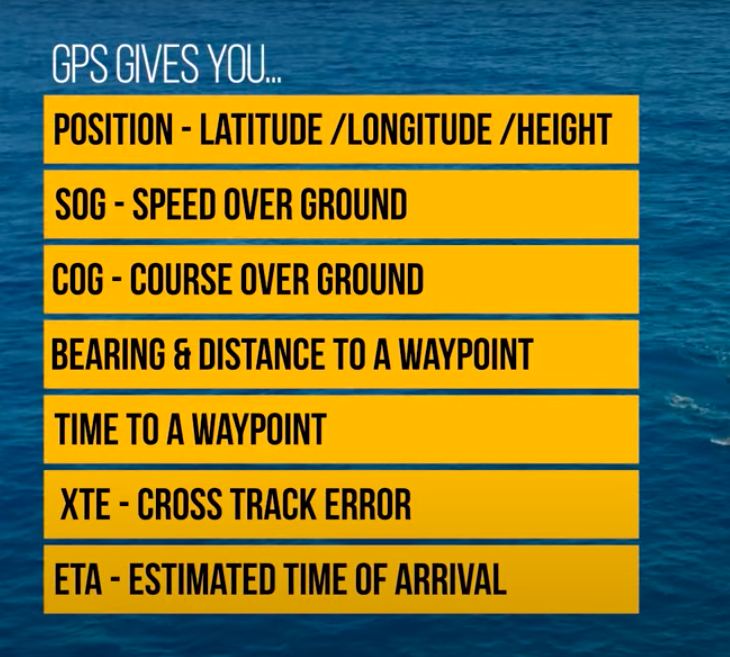
Time Is The Key
GPS is based on time. The satellite signal has an embedded time stamp. Measuring the time it takes for a signal to travel from satellite to receiver provides the distance from the receiver to the satellite.
This results in a circle on the surface of the earth, known as a “line of position” (LOP) of all locations on the earth that are that distance away. Three satellites result in three circles of position, and a latitude/longitude fix of the receiver’s location. Adding in a fourth satellite provides altitude.
GPS (Navstar)
GPS stands for Global Positioning System, and as mentioned earlier, is the United States version of position location using a system of satellites in orbit around Earth.
Originally known as Navstar, the United States has committed to maintaining the availability of a minimum of 24 operational GPS satellites, at least 95% of the time. To meet this goal, 31 operational GPS satellites have been in place for well over a decade as of this writing.
As with all GPS systems, a land based “unit” in contact with four GPS satellites provides a 3D position including latitude, longitude, and altitude with an accuracy of between 3 to 18 feet.
WGS84
The World Geodetic System 1984 (WGS84) is a global datum, used for determining positions on the Earth’s surface.
Fundamentally WGS84 is a coordinate reference system which accurately measures and “marks” locations on the earth. It is used by satellite navigation systems like GPS and in various mapping applications such as in the creation of nautical charts.
WGS84 is the global standard for navigation at sea. Most, but not all nautical charts use WGS84. If the chart you are using has a different datum than your GPS receiver, errors of hundreds (or even thousands) of feet can be the result. One occasion in Mexico’s Sea of Cortez, we were sailing a safe distance offshore. Our chart plotter however indicated we were about 1/2 mile on shore. The chart in the plotter was based on a different datum so that the chart plotter and reality did not match.